| 1 |
董康生, 胡伟波, 沈雁鸣, 等. 美军无人空战装备智能化发展动态及启示[J]. 现代防御技术, 2022, 50(4): 28-37.
|
|
DONG Kangsheng, HU Weibo, SHEN Yanming, et al. Development and Implications of Intelligent Unmanned Combat Aerial Equipment by the US Army[J]. Modern Defence Technology, 2022, 50(4): 28-37.
|
| 2 |
高翔. 视觉SLAM十四讲: 从理论到实践[M]. 北京: 电子工业出版社, 2017.
|
|
GAO Xiang. Fourteen Lectures on Visual SLAM: From Theory to Practice[M]. Beijing: Publishing House of Electronics Industry, 2017.
|
| 3 |
马跃龙, 赵勇, 曹雪峰. 一种基于单目SLAM的无人机序列图像拼接方法[J]. 系统仿真学报, 2016, 28(10): 2349-2355.
|
|
MA Yuelong, ZHAO Yong, CAO Xuefeng. Mono-SLAM Based Method for Stitching Images of Sequence from UAV[J]. Journal of System Simulation, 2016, 28(10): 2349-2355.
|
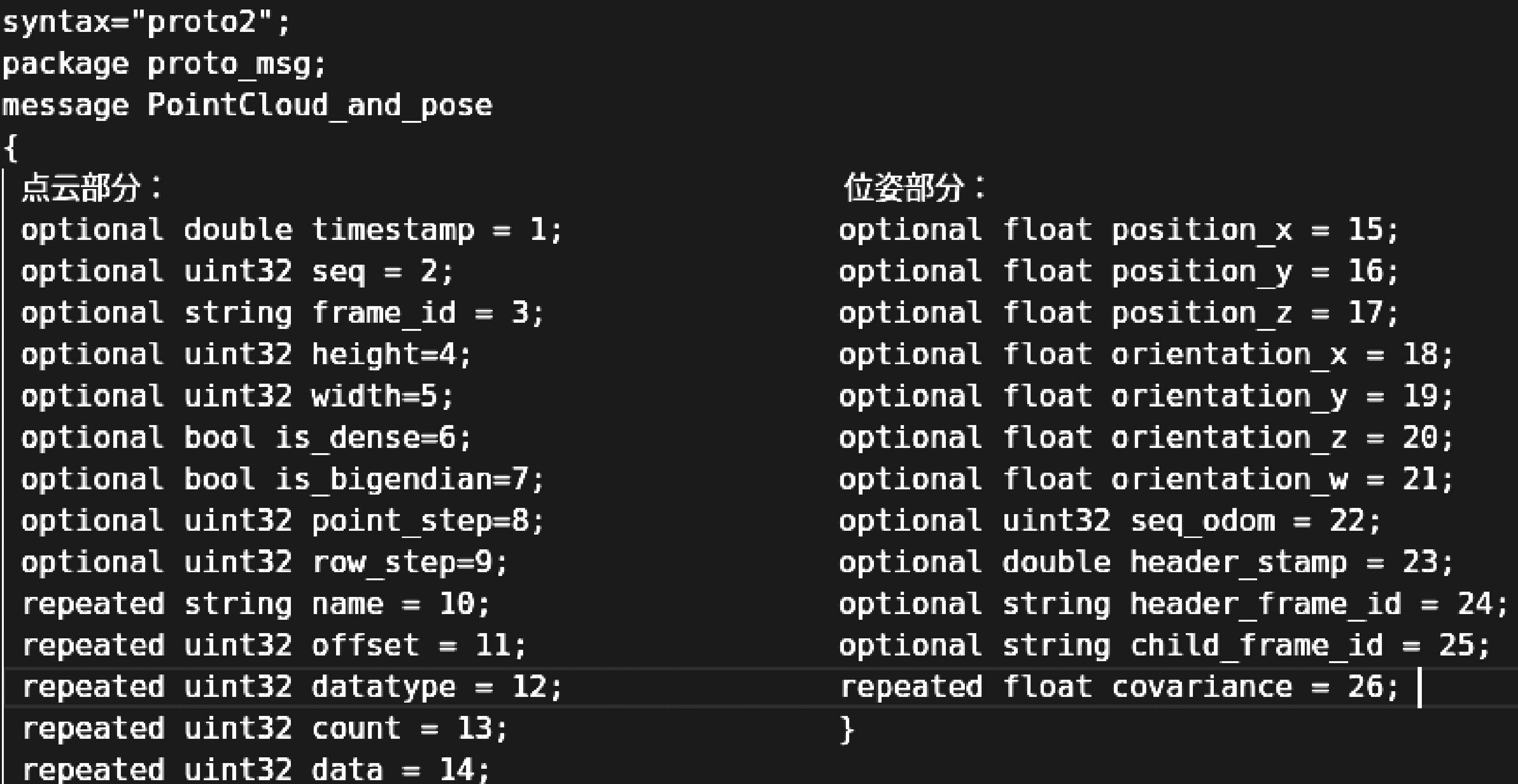
| 4 |
焦嵩鸣, 姚鑫, 丁辉, 等. 适应于环境空间变化的激光雷达SLAM建图方法[J]. 系统仿真学报, 2023, 35(8): 1788-1798.
|
|
JIAO Songming, YAO Xin, DING Hui, et al. Lidar SLAM Mapping Method Adapted to Environmental Spatial Changes[J]. Journal of System Simulation, 2023, 35(8): 1788-1798.
|
| 5 |
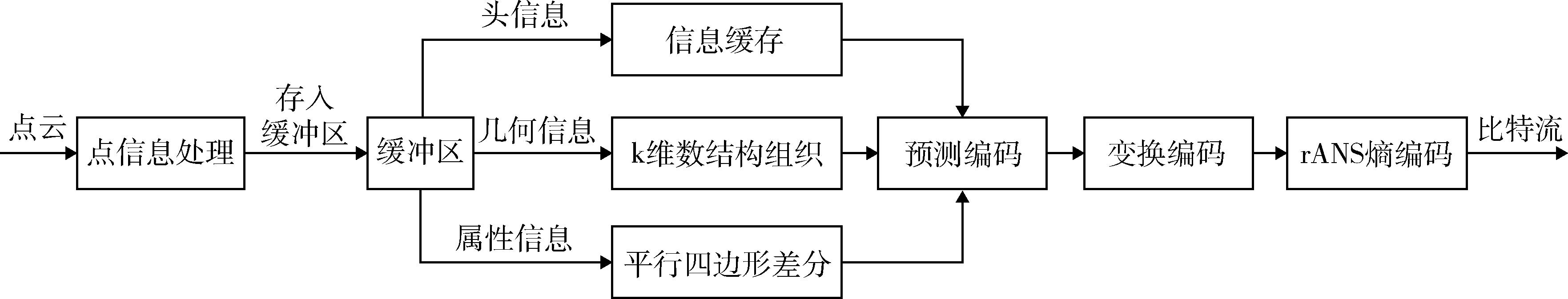
艾达, 卢洪颖, 杨玉蓉, 等. 三维点云数据压缩技术研究综述[J]. 西安邮电大学学报, 2021, 26(1): 90-96.
|
|
AI Da, LU Hongying, YANG Yurong, et al. A Brief Overview 3D Point Cloud Data Compression Technology[J]. Journal of Xi'an University of Posts and Telecommunications, 2021, 26(1): 90-96.
|
| 6 |
DE OLIVEIRA RENTE P, BRITES C, ASCENSO J, et al. Graph-Based Static 3D Point Clouds Geometry Coding[J]. IEEE Transactions on Multimedia, 2019, 21(2): 284-299.
|
| 7 |
SCHNABEL R, KLEIN R. Octree-Based Point-Cloud Compression[C]∥Proceedings of the 3rd Eurographics / IEEE VGTC Conference on Point-Based Graphics. Goslar: Eurographics Association, 2006: 111-121.
|
| 8 |
KATHARIYA B, LI Li, LI Zhu, et al. Scalable Point Cloud Geometry Coding with Binary Tree Embedded Quadtree[C]∥2018 IEEE International Conference on Multimedia and Expo (ICME). Piscataway: IEEE, 2018: 1-6.
|
| 9 |
Google. Draco[EB/OL]. (2022-02-18) [2022-03-24]. .
|
| 10 |
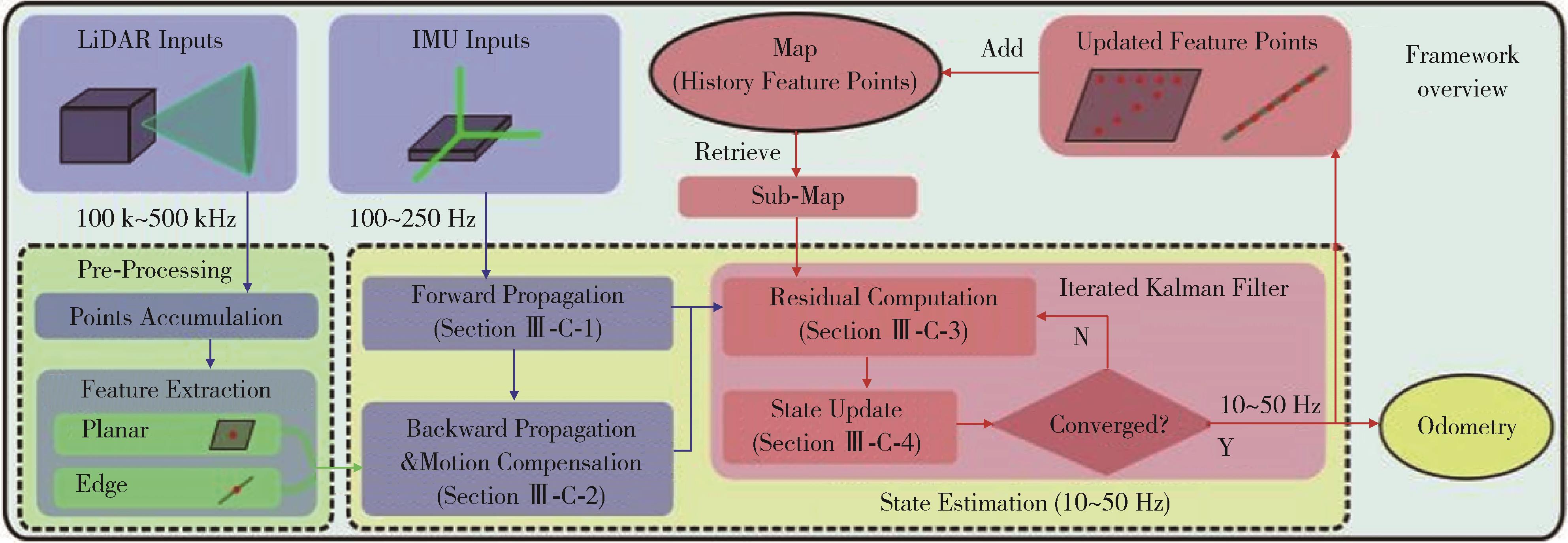
XU Wei, ZHANG Fu. FAST-LIO: A Fast, Robust LiDAR-Inertial Odometry Package by Tightly-Coupled Iterated Kalman Filter[J]. IEEE Robotics and Automation Letters, 2021, 6(2): 3317-3324.
|
| 11 |
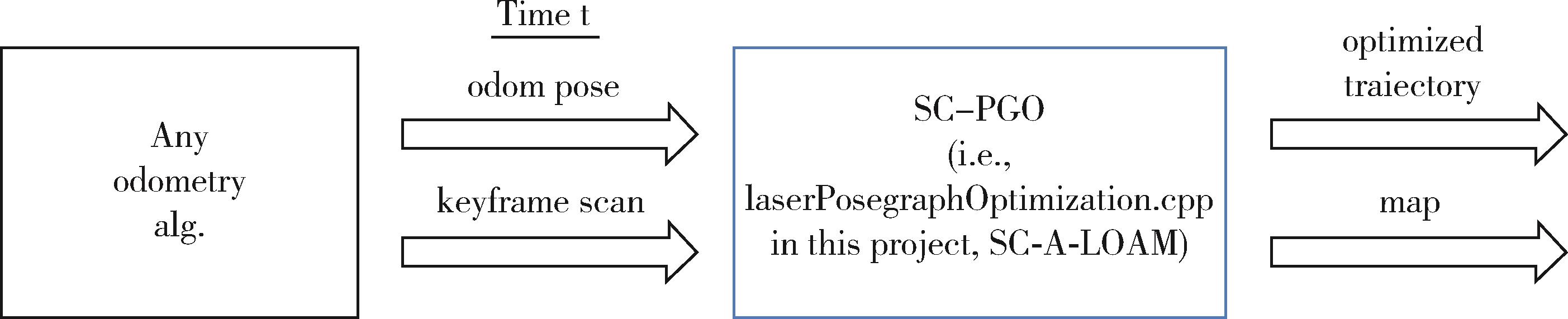
KIM G. SC-A-LOAM[EB/OL]. [2023-05-22]. .
|
| 12 |
JURIĆ A, KENDEŠ F, MARKOVIĆ I, et al. A Comparison of Graph Optimization Approaches for Pose Estimation in SLAM[C]∥2021 44th International Convention on Information, Communication and Electronic Technology (MIPRO). Piscataway: IEEE, 2021: 1113-1118.
|
| 13 |
KIM G, KIM A. Scan Context: Egocentric Spatial Descriptor for Place Recognition Within 3D Point Cloud Map[C]∥2018 IEEE/RSJ International Conference on Intelligent Robots and Systems (IROS). Piscataway: IEEE, 2018: 4802-4809.
|
| 14 |
王阳. 基于图优化的移动机器人SLAM建图算法研究[D]. 杭州: 浙江大学, 2022.
|
|
WANG Yang. Research on SLAM Mapping Algorithm of Mobile Robot Based on Graph Optimization[D]. Hangzhou: Zhejiang University, 2022.
|
| 15 |
ROSSIGNAC J. 3D Compression Made Simple: Edgebreaker with Zip & Wrap on a Corner-Table[C]∥Proceedings International Conference on Shape Modeling and Applications. Piscataway: IEEE, 2001: 278-283.
|
| 16 |
DUDA J. Asymmetric Numeral Systems: Entropy Coding Combining Speed of Huffman Coding with Compression Rate of Arithmetic Coding[EB/OL]. (2014-01-06) [2020-05-10]. .
|
| 17 |
Paplhjak. Draco_Point_Cloud_Transport[EB/OL]. [2023-12-23]. .
|
| 18 |
聂晓旭, 于凤芹, 钦道理. 基于Protobuf的数据传输协议[J]. 计算机系统应用, 2015, 24(8): 112-116.
|
|
NIE Xiaoxu, YU Fengqin, QIN Daoli. Data Transmission Protocol Based on Protobuf[J]. Computer Systems & Applications, 2015, 24(8): 112-116.
|
| 19 |
RoboSense-LiDAR. Rs_Driver[EB/OL]. [2023-12-01]. .
|
| 20 |
CARLEVARIS-BIANCO N, USHANI A K, EUSTICE R M. University of Michigan North Campus Long-Term Vision and Lidar Dataset[J]. The International Journal of Robotics Research, 2016, 35(9): 1023-1035.
|
| 21 |
WANG Jianqiang, ZHU Hao, MA Zhan, et al. Learned Point Cloud Geometry Compression[EB/OL]. ([2019-09-26) [2023-02-03]. .
|
| 22 |
WANG Jianqiang, DING Dandan, LI Zhu, et al. Multiscale Point Cloud Geometry Compression[C]∥2021 Data Compression Conference (DCC). Piscataway: IEEE, 2021: 73-82.
|
| 23 |
GRAZIOSI D, NAKAGAMI O, KUMA S, et al. An Overview of Ongoing Point Cloud Compression Standardization Activities: Video-Based (V-PCC) and Geometry-Based (G-PCC)[J]. APSIPA Transactions on Signal and Information Processing, 2020, 9: e13.
|
| 24 |
LIU Gexin, WANG Jianqiang, DING Dandan, et al. PCGFormer: Lossy Point Cloud Geometry Compression via Local Self-Attention[C]∥2022 IEEE International Conference on Visual Communications and Image Processing (VCIP). Piscataway: IEEE, 2022: 1-5.
|